
Impacted Sites
A site-by-site catalog of cultural heritage impacted since the 2020 Nagorno-Karabakh War, documented through satellite monitoring. Use the filters to search by impact status, site type, and monitoring mission.
Filters
Genocide Memorial
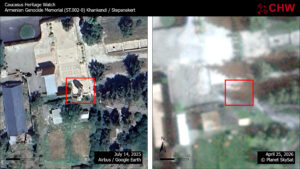
Erected in 2015 to commemorate the 100th anniversary of the Armenian Genocide, the memorial was a white marble bell tower at the end of a modest open plaza. The structure housed a reliquary containing human remains from Der Zor -— the Syrian desert town where hundreds of thousands of Armenians perished in 1915. Satellite imagery from Airbus and Planet shows that the monument, as well as the associated memorial complex, were destroyed between October 12, 2025 and April 25, 2026.
St. Jacob Church
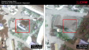
St. Jacob (Surb Hakob) Church was constructed between 2005 and 2007 to serve as a primary place of worship for the local Armenian Apostolic community. Built in traditional Armenian ecclesiastical style with stone masonry and a central dome, the church functioned as a central parish church in the city prior to September 2023. Satellite imagery shows the church still extant in October of 2025. The building was razed and the site graded by April 25, 2026. In news reports the government of Azerbaijan confirmed the demolition.
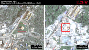
Ghazanchetsots St. Amenaprkich Cathedral
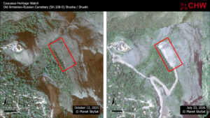
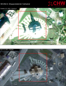
The 20th century history of Ghazanchetsots Cathedral in Shusha/Shushi is closely tied up in the patterns of war and tragedy that have impacted the town as a whole. Most recently, Azerbaijan’s forces targeted the building during the 2020 war, leaving a shell hole in the southern roof. The surrounding grounds have been impacted in the years since, including the demolition of a carved stone in the yard documented by CHW in monitoring report #1 and the steady erasure of the ornate walkways. By April 25, 2026, the decorative walkways had been completely erased. And by July 23, 2026, a massive building program had commenced on the grounds with four visible new buildings rising and large debris heaps east and north of the cathedral.
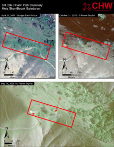
Parin Pizh Cemetery
Satellite imagery shows both demolition and earth clearing in the area of Parin Pizh cemetery. The cemetery is clearly visible in Google Earth high-resolution imagery from April 2024. A Skysat image from October 31, 2025 indicates the beginning of what appears to be a localized demolition project marked by arrow A. By May 2026, the demolition project seems to have gotten larger (arrow A) and has been joined by a bulldozed or graded path that cuts through the cemetery from the pre-existing road (arrow B) to the demolition site, damaging several tombs.
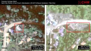
St. Astvatsatsin Church
CHW has assessed the Holy Mother of God church in the village of Boyuk Galadarasi/Mets Shen (Shusha region) as under heightened threat. Using @Planet imagery, CHW documented earthmoving activity immediately to the east and north of the historic structure between Oct. 31, 2025, and May 14, 2026.
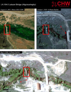
Lalazari Bridge
The Lalazari, or Lalazar, bridge was built in 1867 by Hovakim Lalazariants from Khendzoresk. It was later repaired by his son Simeon between 1900 and 1902. A construction inscription in Armenian was engraved above the bridge’s downstream facade. In the Soviet period, this inscription was scraped away.
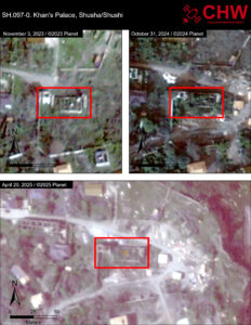
Khan’s Palace/Haji Gulu’s Mansion
This two-story structure, today in ruins, was the residence of the Shusha Khans. Formerly, it consisted of two buildings with walls made of whitewashed stone. Google Earth imagery suggests that a portion of the structure may have remained extant through 2004. But by August 2013 the entire structure had been reduced to a few standing segments of walls. CHW is concerned by the extensive earthmoving and construction in the area surrounding the palace. It is possible that this work heralds an impending effort at restoring the structure. But for the moment, current evidence only indicates a worrying amount of potentially destabilizing activity in the area.
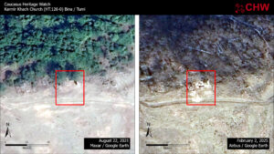
Karmir Khach Church
One of the oldest churches in Karabakh, the original name of this medieval church is not preserved. It is known in Armenian as Karmir Khach, or “Red Cross”. According to a founding inscription, the church was built by the sister of Gagik I in the year 1000 “for the salvation of my soul and my parents.” Google Earth imagery shows that the foundations of the “Red Cross” church were dug into and dirt piled to the southwest between August 22, 2021 and February 2, 2025.
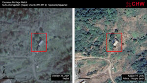
St. Amenaprkich (Napat Vank) Monastery
Satellite imagery shows the removal of the metal roof from the St. Amenaprkich monastery near Tepekend/Tonashen. The impact appears to date between October 2024 and April 2025. A high-resolution image from Google Earth shows the extent of the damage. The removal of metal roofs from heritage sites fits a pattern of what CHW has elsewhere described as “heritage mining.”
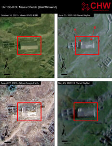
St. Minas Church
Satellite imagery shows the partial removal of the metal roof of St. Minas Church. The baseline image shows the church undisturbed. An image from June of 2025 shows an undefined impact to the northwestern edge (arrow A) and the removal of the roofing from the entire eastern (arrow A). The subsequent August 2025 and May 2026 images demonstrate the extent of the damage.
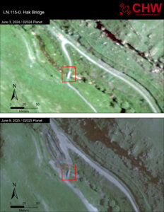
Hak Bridge
This asymmetric double-span bridge on the southern side of the village of Hak was built in the early 20th century. Satellite imagery from June 9, 2025 shows extensive work being conducted to widen the roadbeds both north and south of the bridge. It is unclear at present if this work will circumvent the historic bridge or lead to its ruin, as CHW has documented in the cases of other historic bridges in the region.
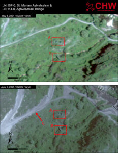
Aghvesahaki Bridge
The Aghvesahaki Bridge (B in the satellite imagery), located just south of St. Mariam Astvatsatsin church, was built of local rough-hewn basalt and lime mortar. The bridge has no construction record but Monument Watch suggests it dates to the 18th century based on architectural details. Satellite imagery from June 9, 2025 indicates a concerning new road construction project cutting just 33m from St. Mariam Astvatsatsin. This work has already been extensive enough to build up sizeable berms in the area.
St. Mariam Astvatsatsin
St. Mariam Astvatsatsin (A in the satellite imagery) consists of two adjacent rooms built of local undressed stone held together with lime mortar. A 1419 inscription on the southern wall of the eastern room names the cells “Tiramayr Astvatsatsin” and “Surb [St.] Grigor”. There are a number of tombstones and khachkars (cross stones) in the vicinity of the church including one dating to 1413. Satellite imagery from June 9, 2025 indicates a concerning new road construction project cutting just 33m from St. Mariam Astvatsatsin. This work has already been extensive enough to build up sizeable berms in the area.
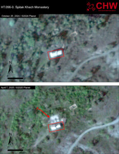
Spitak Khach Monastery
The founding date of the Spitak Khach monastery is unknown, but the oldest preserved inscription, located under the khachkar of the northern arch, is dated to 1333. Additional inscriptions testify to regular renovations of the structure over the centuries. Satellite imagery from April 2025 shows rectilinear disturbances (A) to the territory immediately north of Spitak Khach. It is unclear from the available imagery what these disturbances represent.
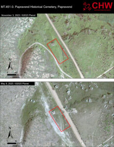
Papravend Historical Cemetery
This cemetery appears on the list of heritage sites of the Republic of Azerbaijan (inventory No. 5750) as an archaeological monument dating to the medieval era. The cemetery consists of two components–a large field of tombs east of the north-south road and a smaller area of burials to the west. In CHW’s Special Report #2, “Between the Wars”, we concluded that the site had suffered major damage between 2011 and 2020, during the administration of the unrecognized Nagorno-Karabakh Republic. In CHW’s Spring 2025 monitoring mission, we observed a new threat to the western extent of the cemetery. Earth moving equipment appears to have scraped the territory near the west side of the cemetery.
Zar School
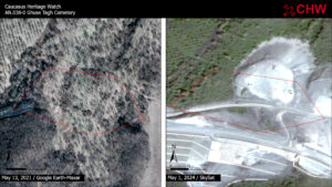
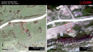
Satellite imagery shows that between November 5, 2023 and June 1, 2024, the ruins of the school building of Zar/Tsar was demolished. Embedded in its walls were hundreds of fragments of medieval “spolia”, stone elements taken from nearby medieval Armenian monasteries, churches, and cemeteries that had been destroyed just a few years prior.
Chirag School
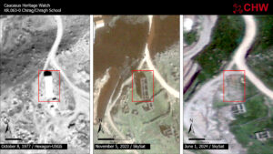
Satellite imagery shows that between November 5, 2023 and June 1, 2024, the ruins of the school building of Zar/Tsar was demolished. Embedded in its walls were hundreds of fragments of medieval “spolia”, stone elements taken from nearby medieval Armenian monasteries, churches, and cemeteries that had been destroyed just a few years prior.
Kohak
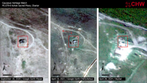
This sacred place appears to have been initially impacted by shelling during the Fall 2020 war. An April 14, 2021 image shows the central area has collapsed and stone ejecta litters the area to the northwest suggesting a strike from the southeast. Most of the site was destroyed by October 2023 and by April 28, 2024, earthmoving and construction appear to have destroyed the last remnants of the sacred place.
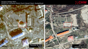
St. Hovhannes Mkrtich Church (Kanach Zham)
St. Hovhannes Mkrtich Church (known as Kanach Zham) was significantly impacted during the Second Nagorno-Karabakh War in 2020, as reported in CHW Monitoring Reports #1 and #2. However, imagery released on Google Earth from April 4, 2024 clearly shows the complete demolition of the church.
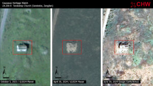
Tandzatap Church
There is little information about the construction history of the Tandzatap church but Monument Watch assigns it to the second half of the 19th century based on stylistic features and historical analysis. Satellite imagery shows that between October 5, 2023, and April 30, 2024, the church sustained major damage. Most of the roof collapsed, as did the southern wall which featured an embedded stone engraved with a cross.
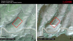
Kanach Tala Cemetery
Impact to the cemetery is first visible in an October 5, 2023 image that shows the initial earthwork for what would subsequently emerge in later imagery as a terrace intended to stabilize the slope above a new roadway. As of the most recent imagery, the terrace construction has impacted approximately 16% of the recorded territory of the cemetery.
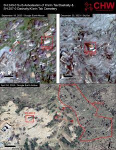
Karin Tak Cemetery
The cemetery of Dashalty/Karin Tak faces a significant threat due to the demolition of almost the entire adjacent village during late 2023 and early 2024. Bulldozer scars provide visible signs of grading along the western limit of the cemetery. CHW assess the cemetery as at high risk of erasure.
St. Astvatsatsin of Dashalty/Karin Tak
The Surb Astvatsatsin church of Karin Tak sits on the eastern side of the historic Armenian village. According to inscriptions on the church facades, it was built in 1841 and renovated in 1903. A September 18, 2020 image shows the initial stage in the construction of a new mosque (A) amidst the standing houses of the village. A December 20, 2023 image shows work on the mosque continuing even as the homes of the entire village have been razed. Only a single structure remains standing amidst the ruins: Surb Astvatsatsin church. By April 4, 2024 the bulldozers had demolished the village, approaching the edge of the cemetery (B). The church remains standing amidst the debris.
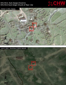
St. Grigor of Zar/Tsar
The churches of St. Sargis and St. Grigor, in Zar, are both single nave chapels built in the 13th century. Between October 5, 2023 and June 2, 2024, the standing ruins of Zar were removed and the terrain graded. Only the two Armenian churches remain standing.
St. Sargis of Zar/Tsar
The churches of St. Sargis and St. Grigor, in Zar, are both single nave chapels built in the 13th century. Between October 5, 2023 and June 2, 2024, the standing ruins of Zar were removed and the terrain graded. Only the two Armenian churches remain standing.
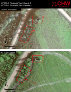
Ptkataghi Cemetery
All that remains of this 17th century monastery are the ruins of its church (A), a single-naved hall with semicircular apse on the eastern side. More information about the church can be found at the link. The cemetery (B) sits in the forested area to the southwest of the church. Between October 8, 2023 and April 20, 2024 a 7-8m wide path was cut that skirted around the northwest corner of the church and intruded into the southeast corner of the cemetery (C).
Ptkataghi Vank
All that remains of this 17th century monastery are the ruins of its church (A), a single-naved hall with semicircular apse on the eastern side. More information about the church can be found at the link. The cemetery (B) sits in the forested area to the southwest of the church. Between October 8, 2023 and April 20, 2024 a 7-8m wide path was cut that skirted around the northwest corner of the church and intruded into the southeast corner of the cemetery (C).
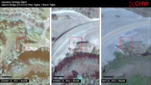
Halevor Bridge
Halevor bridge spanned the Ishkhanaget/Quruçay river 2km southwest of Böyük Tağler/Mets Tagher. CHW provisionally assessed the bridge as damaged in our October 2022 report when satellite imagery (top right) was not conclusive. April 2023 imagery now shows that the span has been destroyed by ongoing road construction.
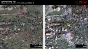
Ghazanchetsots Cemetery
CHW initially documented damage to the Ghazanchetsots Armenian cemetery in Shusha/Shushi in Fall of 2023. Subsequent imagery from Spring 2024 indicated that the entire territory of the cemetery had been razed and the surface graded.
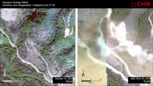
Cemetery near Vazgenashen / Hajisamly
This 14th-16th century cemetery is reported to contain carved cross stones (khachkars), including one inscribed in Armenian dating to the 14th century. Our initial report on damage to the site in June 2023 noted encroachment into the territory of the cemetery on the southern and northeastern edges. Since that time, a significant area of the cemetery has been damaged by continued earth moving activity along the eastern margin. A 2011 plan compiled by the unrecognized Republic of Nagorno-Karabakh shows the outline of the burial ground’s preservation zone. Most of the khachkars in this cemetery are embedded in the ground, so it is not possible from satellite imagery to determine how many have been destroyed.
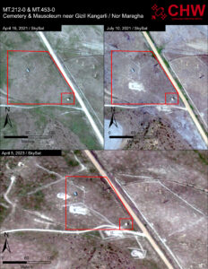
Cemetery near Gizil Kangarli / Nor Maragha
The cemetery near Gizil Kangarli / Nor Maragha (MT.212-0, large red box in the satellite images) was first impacted between April and July of 2021 when a military emplacement was dug near the center of the site. Between October 2022 and April 2023, additional positions were excavated in and around the cemetery. In the southeast corner of the cemetery stands a single mausoleum (MT.453-0). CHW assesses the cemetery as significantly damaged by the military construction in the area. And we assess the mausoleum as severely threatened both by active construction and by the potential of the area to become a target in the event of renewed hostilities. Placing military installations in proximity to heritage sites is a violation of Article 4(1) of the 1954 Hague Convention which Azerbaijan ratified in 1993. The mausoleum can be seen in the image below with the area of the cemetery in the foreground.
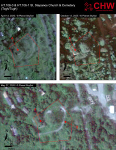
St. Stepanos Church & Cemetery
St. Stepanos Church is a rectangular vaulted hall built of rough-hewn stone. There is a khachkar embedded in the church’s western facade that has the following inscription: “In the year of 1531, I, Friar Daniel erected it.” The gravestones of the cemetery surrounding the church have a range of distinct decorative motifs and some also have Armenian language inscriptions. The area was intact throughout 2025. By May 27, 2026, earthmoving had scraped a path across the northern extent of the cemetery.
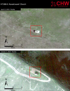
Kavakavank Church
Kavak’avank’ Church is the only standing structure from what was once a monastic complex. On July 1, 2023 Monument Watch issued an alert that the site was being altered based on a video posted on Facebook. The video shows work being done on both the interior and exterior of the church, including the emplacement of a new lintel over the entry. Satellite imagery from October 5, 2023 confirms new ongoing work at the site, most visible as a newly bulldozed road leading to the front entrance of the church.
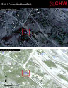
Amenaprkich Church
Surb Amenap’rkich Church in Talish was built in 1894 as a vaulted three-nave basilica. Construction began on a new housing development in Talish during the third quarter of 2022. Between October 2022 and April 2023, this development expanded dramatically to the southwest, coming less than 100m from the historic church.
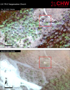
Vazgenashen Church
The Vazgenashen Church is located 1km north-west of Vazgenashen/Hajisamly village in the Lachin district. The church dates to the 15-17th centuries. There are two cross-stones (khachkars) dating to the same period at the site. April 2023 imagery shows that the same roadwork that has damaged portions of LN.177-0 (Cemetery near Vazgenashen) also threatens the remains of the church with a new road cut just 25m to the south.
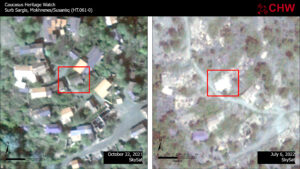
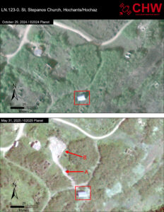
St. Stepanos Church
The construction date of the church is not known but Monument Watch assigns it to the second half of the 17th century based on its architectural features. Satellite imagery from May 31, 2025 shows a concerning new road cut directly across from the historic church. The road terminates in a depot where a construction vehicle is visible.
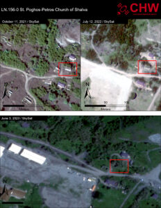
St. Poghos-Petros Church
St. Poghos-Petros Church of Shalva was constructed of rough stones held together with lime mortar. A large number of khachkars and tombstones were reused as building stones for the church’s walls, including three with Armenian inscriptions dated to the 17th century. Construction of a new complex adjacent to the church began between April and July of 2022. Recently, the appearance of new facilities and vehicles in the area raises the possibility that the construction will encroach more immediately on the site of the church.
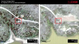
St. Yeghishe of Mataghis
An inscription carved above the southern entrance of St. Yeghishe reads: “The Church of St. Yeghishe was built by the united people of Mataghis. It was started in 1892 and was completed in 1898.” CHW’s satellite imagery shows earthmoving immediately to the east and north of the church between October and 2021 and July 2022.
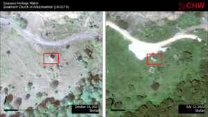
Zorakhach Church
The construction date of Zorakhach church is not known, but gravestones of the 16th and 17th centuries were re-used in its construction, providing a terminus post quem for the building. The structure is a typical single-nave basilica with an altar on the eastern side. Satellite imagery shows an extensive earth moving operation underway just adjacent to the historic Church.
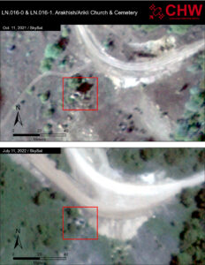
Arakhish Church
There is no construction date for the medieval church but the cemetery contains cross-stones (khachkars) dated to the 12th-16th centuries. More than 20 engrave cross stones, or khachkars, have been documented in the surrounding graveyard. Between October and July, satellite imagery shows extensive new earthmoving and road construction activity immediately to the northeast of the church and its adjacent cemetery.
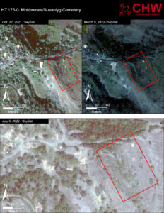
Mokhrenes Cemetery
The 19th century cemetery at the eastern edge of the village of Mokhrenes/Susanlyg appears largely intact, despite the widespread destruction of the village (see entry for St. Sargis church, HT.061-0). The reach of the destruction extends just to base of the hill on which the cemetery is located. Given the apparent targeting of Mokhrenes for demolition, the historic cemetery is designated as threatened.
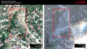
Mets T’agher Cemetery
An Armenian cemetery in the village of Mets Tagher/Böyük Tağlarhas been destroyed. The cemetery was founded in the early 19th c. and was in use when Armenians evacuated the village in 2020. Satellite imagery shows its complete destruction. Signs of bulldozer scars
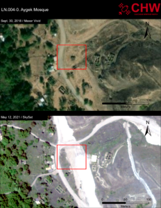
Sgnakh Cemetery
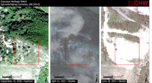
The entire area of this cemetery has been deeply graded, with bulldozer scarring clearly visible. The initial attack on the site is visible in the April image in the form of bulldozer cuts flnaking the cemetery to the north and southwest. By the June image, the entirety of the cemetery has been scraped away and the adjacent forest damaged. The July image shows an area of rough stone blocks northeast of the cemetery that is likely the remains of the destroyed grave markers.
Makun Bridge
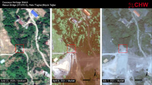
The Makun bridge in Mets T’agher/Böyük Tağlar, which spanned a small tributary of the Guruchay/Ishkhanagat River, appears to have been destroyed by road construction. A series of images from April through July 2021 show extensive earthmoving in the area of the bridge attendant to an effort to canalize the stream prior to paving the newly expanded road.
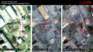
Meghretsots St. Astvatsatsin Church
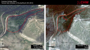
CHW issued an initial damage assessment for SH.054-0 in Monitoring Report #1 from June 2021. At that time, satellite imagery indicated damage to the north wall (arrow A) sustained most likely as a result of the 2020 war. New imagery from November 3, 2023 indicates that demolition debris (arrow b) was recently dumped on the foundations of the old church, likely using heavy machinery.
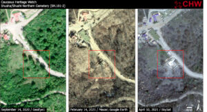
Northern Cemetery of Shusha/Shushi
The centuries-old cemetery north of Shusha/Shushi has been partially destroyed. A portion of the grounds on the west side of a road leading into the city was leveled in the construction of a building complex. The expansive cemetery, which spans both sides of the road, contained 96 tombstones dating 1832-1920 and two 12-13th c. cross stones (khachkars), including the tombs of noble Armenian families (meliks). Although the construction occurred in an area shaded by tree cover, imagery from February 2021 reveals a dense array of tombstones, and documentation provided by Monument Watch details specific plots in the location.
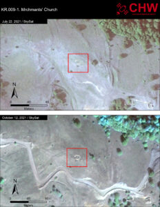
Mrchmants Church
As of 1911, this church was still standing. When N. Ter-Movsisyan visited the site in that year, he remarked that “a small basilica church remains standing, made of ordinary stones with a small door” (Karapetyan 2019: 356). The church was largely destroyed during the Soviet period when it was reduced to its foundations. Fragments of its foundation inscription and other stones were reused in the construction of a school in the village while it was part of the Azerbaijan S.S.R. The inscription included the date A.D. 1304. October 12, 2021 imagery shows a new bulldozer scar for a roadbed crossing within 40m of the surviving foundations.
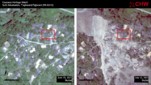
St. Astvatsatsin Church
This 19th century church is assessed to be at high risk due to road construction in the area. A wide swath has been bulldozed through the village of T’aghavard/Tağaverd with earth moving resulting in the destruction of numerous structures. The destruction of standing architecture extends right up to St. Astvatsatsin.
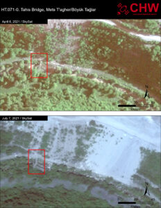
Tahis Bridge
This late Medieval bridge located between the villages of Mets T’agher/ Böyük Tağlar and Togh is threatened by road construction. The bridge sits in a stream bed well below the grade of the road. However, July 2021 CHW imagery indicates that significant amount of spoil from extensive earthmoving along the road is cascading into the streambed, presenting a significant threat to the integrity of the bridge.
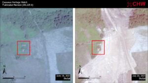
Tukhnakal Mansion
This 18th century mansion had been set back from the roadway by approximately 60m. Large-scale earth moving and bulldozer scars are visible directly adjacent to the eastern facade of the complex. According to Monument Watch, oral histories attribute the mansion to the Dolukhanyans, a noble family known from 19th century sources.
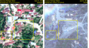
Amenaprkich Church
Extension construction activity just east of the church constitutes a significant threat. The bulldozed area just east of the church hosts a number of construction vehicles. This activity is located just south of the road building work that destroyed Mets Tagher cemetery.
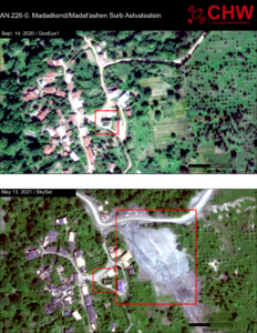
St. Astvatsatsin Church of Madadkend/Madatashen
This already fragile 19th century church sits just 50m from extensive earth moving adjacent to the road. Satellite imagery shows an extensive area of bulldozing just south of the road in what formerly was agricultural territory.
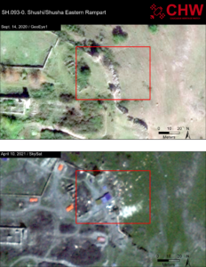
Eastern Rampart
A portion of the historic city rampart appears to have been damaged, most likely during the 2020 conflict, based on the ejecta pattern of some of the debris. In the imagery, the area appears to host temporary structures (visible with orange and purple roofs).